Reading time: minute(s)
 Deutsch
 English
 Français
FAQ - Frequently asked questions
In this section you will find answers to frequently asked questions. These are organized by subject area.
 General
Supported Operating Environments
General
Supported Operating Environments
|
Question: |
What are the supported operating environment for PTV Map&Guide? |
|
Answer: |
PTV Map&Guide is intended for use with a locally installed, supported web browser on a dedicated workstation. Terminal server environments, including Microsoft Remote Desktop Services (RDS), Citrix Virtual Apps and Desktops, and comparable multi-user environments, are not among the supported operating environments. Performance, stability, and functionality cannot be guaranteed for installations in such environments. |
Hardware Acceleration (GPU) Requirements - Why hardware acceleration matters
|
Question: |
I'm using PTV Map&Guide via a terminal server connection. The program is extremely slow, and I'm seeing high CPU usage. What can I do to improve performance? |
|
|
Answer: |
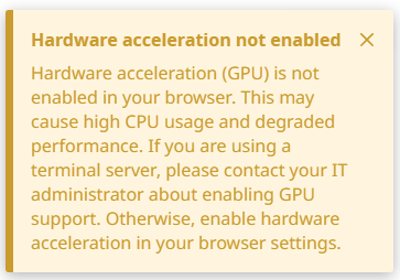
PTV Map&Guide uses WebGL technology to render interactive maps and visualize routes in real time. WebGL relies on your computer's graphics processing unit (GPU) to perform these rendering tasks efficiently. When hardware acceleration is disabled in your browser, all graphics rendering falls back to software-based processing on the CPU. This causes:
Enabling hardware acceleration allows the GPU to handle graphics workload, keeping CPU usage low and ensuring a smooth user experience. |
|
|
||
|
Solution: |
How to check if hardware acceleration is enabled:
How to enable hardware acceleration
|
|
|
Troubleshooting: |
If hardware acceleration is enabled in your browser settings but the application still reports it as disabled:
If the issue persists after trying all steps above, please contact your IT administrator to verify that GPU access is not restricted by a group policy or system configuration. |
 How can I create a browser bookmark for PTV Map&Guide?
|
Question: |
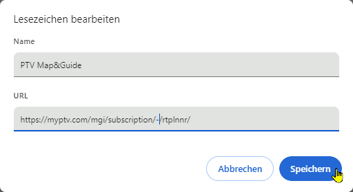
I would like to create a bookmark in my browser to access the route planner. However, the address of the website contains a long, untraceable character string. This string is dynamic. This means that the link may be invalid the next time I try it. |
|
Answer: |
|
| Result: | The next time the bookmark is called up, the character string is regenerated, but the link in the bookmark does not lose its validity. |

 Data management
Which coordinate formats can I import into the data management?
Data management
Which coordinate formats can I import into the data management?
|
Question: |
My import in the data manager fails. A message alerts me to possible data format problems. What format must the coordinates of the addresses to be imported be in? |
|
Answer: |
A point on a map is always described by a pair of coordinates, the latitude and the longitude. In PTV Map&Guide, addresses can be imported and geocoded based on their coordinates. The following coordinate formats can be used for the import:
|
Tender+
Which coordinate formats can I use in Tender+?
|
Question: |
What format must my coordinates have so that I can perform an automatic calculation with Tender+? |
||||||||
|
Answer: |
A point on a map is always described by a pair of coordinates, the geographic latitude and the geographic longitude. In Tender+, addresses can be imported and geocoded based on their coordinates. To do this, enter the longitude in the “Longitude” column and the latitude in the “Latitude” column. The following coordinate formats can be imported:
|